By Sandra LaVigne, Director of Water Quality Programs
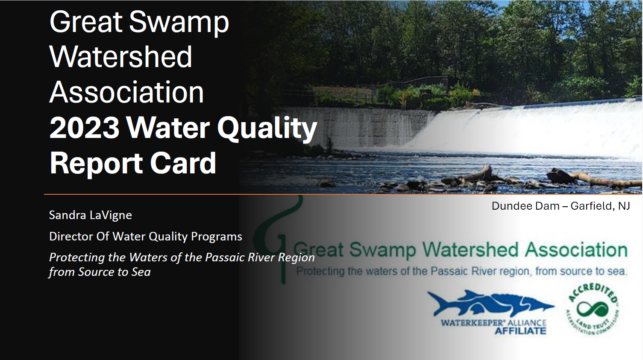
Sandra LaVigne collecting WQ Samples at Dundee Dam.
Throughout 2023, GSWA completed our annual water quality monitoring including quarterly chemistry sampling, macroinvertebrate sampling, bacterial sampling, and visual assessments. Overall, GSWA staff and volunteers monitored thirty-three discrete sites along the Passaic River and the Great Swamp Watershed tributaries. This was the first year of our latest Passaic River Expansion bringing us downstream as far as Dundee Dam in Garfield. Since 2017, GSWA has been expanding our knowledge of the water quality along the Passaic River. Every three years since then we have moved further downstream with our sampling efforts, connecting with new communities and learning about the issues facing the different regions of the Passaic River. The 2023 expansion includes the stretch of the Passaic River between Little Falls and Dundee Dam. This area of the river surrounds the majority of Paterson and brings us into an increasingly urban region of the watershed.
In the expansion area between Little Falls and Dundee Dam, nitrogen levels at all four sites were elevated above the EPA standards on at least two out of four of our sampling days. While nitrogen is essential for the healthy growth of aquatic plants, excessive amounts can work like fertilizer dramatically increasing plant growth and increasing the likelihood of algal blooms in the slower-moving areas of the river. Harmful algal blooms of blue-green cyanobacteria have been an increasing issue in New Jersey’s water bodies over the last few years. The increase and severity of rain storms in our area leads to higher levels of contaminants entering our streams through stormwater runoff. This runoff can be one source of the excessive nitrogen levels in our streams. However, in Paterson, there is another major potential source of nitrogen and that is the combined sewer overflow. This system combines the wastewater sewage from homes and businesses in Paterson with the stormwater runoff from the street drains. When too much water volume enters the system, the excess of mixed sewage and stormwater is diverted into the river. This partially untreated sewage can contain not only high levels of nitrogen but bacteria as well.
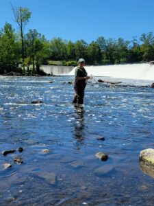
Flooding at Paterson Great Falls.
In 2023, the precipitation patterns were notable for long dry spells followed by strong rains that often exceeded more than an inch of rain within a twenty-four hour period. We had four months that had more than two inches of rain above the normal monthly average, including the wettest December on record since 1895. With a December storm that had record rainfall amounts of over five inches in some areas of the Passaic Watershed. The resulting runoff entering the Passaic River from this storm alone caused flooding levels more than 10 feet above normal flow at the Little Falls USGS monitoring station.
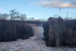
Flooding and erosion at the CMA.
Flooding and runoff from strong storms impacted some of our Great Swamp Watershed streams as well. The Silver Brook which runs through the GSWA Conservation Management Area(CMA), has been impacted by issues of erosion and increased nutrient loading, with higher than usual nitrogen and phosphorus levels being noted at some locations in May and November, both of which were collected following major rain events. However, the effects of the restoration project carried out at the CMA in 2020 are shown in the increased amount of stormwater runoff that is now being held on the property. This helps to reduce the impacts of flooding in areas further downstream. This slower movement of water through the CMA also allows for more of the excess nutrients being brought in to be filtered out by the wetland vegetation. Water quality samples collected at the downstream sampling location along the Silver Brook, showed lower nutrients than the samples collected at the upstream site, showing that the forested floodplain areas in the CMA are functioning properly to filter the water.
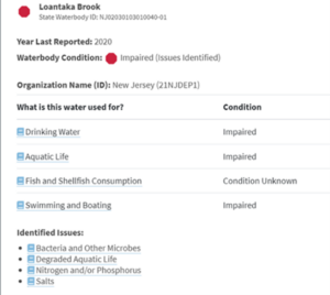
NJDEP 303d List standings for Loantaka Brook.
As Loantaka Brook continues to be the most impaired tributary within the Great Swamp Watershed area, and is listed as impaired in the NJDEP 303d Water Quality list for issues with bacteria levels, nutrient loading and low macroinvertebrate diversity. To further understand the issues impacting the stream GSWA collected extra water quality data in the headwater region of the brook during our fall sampling. This data showed significantly elevated nitrogen levels and total dissolved solids (a measure of road salt). GSWA is using these data as well as historic data results to work with the communities in the Loantaka watershed area to develop a Watershed Restoration and Protection Plan. This plan will layout strategies to restore and improve the water quality within Loantaka Brook and also help the local municipalities meet the new stormwater regulations being implemented in NJ.
Hazel England helping to collect PFAS samples at Rolling Knolls Superfund site
Finally, in November GSWA staff conducted follow-up PFAS sampling along Black Brook and in the Rolling Knolls superfund site area. PFAS continue to be an issue of concern, these forever chemicals are ubiquitous in our environment, and increasing regulations about the acceptable levels in the water are being implemented at both the state and federal levels. In November we sampled seven locations, four along Black Brook and three within the marsh area at the Rolling Knolls superfund site. As with our previous findings, every site contained some level of PFAS contamination. The three sites at Rolling Knolls, contained the highest number of contaminants with one site testing positive for twelve out of the thirty-six PFAS compounds tested. Two of the Rolling Knolls sites tested extremely high for the compound perfluorooctanesulfonic acid (PFOS) one of the compounds currently regulated in drinking water by NJ. The levels found at these sites were up to four orders of magnitude higher than the levels set for drinking water. The samples collected in Black Brook covered sites both upstream and downstream of the Rolling Knolls site. The samples collected upstream had significantly lower levels of PFAS compounds and in lower quantities than the downstream sites. This data will be presented to the community and the EPA to help determine the best and most environmentally sound solution for resorting the Rolling Knolls Superfund site.
Findings are compiled into our annual Water Quality Report Card. Morristown & Morris Township Library on Miller Road in Morristown. You can read the full 2023 Water Quality Report Card with data results – HERE
For more about our Water Quality Testing Program, the 21 locations annually monitored for a suite of chemical parameters, and how to volunteering for this project for this project – CLICK HERE
GSWA is the only entity, non-profit, corporate, or government, monitoring the five main streams of the Great Swamp Watershed and Passaic River on a consistent basis. Consider donating to help ensure GSWA will continue to be here to monitor and protect the Great Swamp Watershed and Passaic River for many generations to come. https://www.greatswamp.org/donate